Mweenish Island — a lovely island for a stroll if you're sure of the tides
And check out Glasheen Island and the large Tawin Island here in Galway
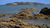
Mweenish Island — a lovely island for a stroll if you're sure of the tides

Mweenish Island, County Galway.... near Island Eddy. Picture: Dan MacCarthy

Most of County Galway’s myriad islands lie west of the city in the heart of Connemara. The island-studded Kilkieran Bay has many, as has Roundstone Bay. However, there are others that lie to the south of the county, down as far as Kinvara, and some are of significant size. Recently we had a look at the adorable Island Eddy [link below] and its neighbour Fiddaun Island, sometime home to the rare Forster’s tern.

This entire area of Galway Bay has had a very changeable past with islands being broken up and reformed over the aeons. Geographic loyalties count for nothing as being part of one island for a long time means nothing if the great forces of nature decide to destroy and rebuild.

The entire terrain of Mweenish is very flat with its southern shores comprised of shingle and its northern gradually giving way to sand. The neighbouring islands are all very flat too.

A 19th century geographer (C.A. Cotton) described the area as: “Mweenish Island is made up of three drumlin-shaped portions connected by narrow necks, presumably tombolos”. There is another classic tombolo system at Castlegregory in County Kerry where the Seven Hogs are connected to the mainland by underwater sandbars.

The island has three distinct sections: the eastern part that ends at Mweenish Point, the largest central section whose ends taper to the extremities; and the western section known as Knockmore. In all, Mweenish Island is a sizeable 68 acres. Beyond Knockmore, and barely linked by a rubble bar, is Ballynacourty Point which in turn leads to Glasheen Island. The famous 19th-century engineer of piers, Alexander Nimmo, built several piers in the region to help develop the fishing industry and bring an improved economy to the people.

Glasheen Island in turn, stretches towards and almost reaches the large Tawin Island which once had a population of more than 100 people but all the other aforementioned islands were unpeopled. Mweenish, apart from Knockmore, is not farmed due to the poor soils.

The tides on the northern shore have swept the shingle to a quiff-like point.

On the southern side, the tides have raised a huge shingle embankment that runs the length of the island, and which actually prevents the island from being eroded away.

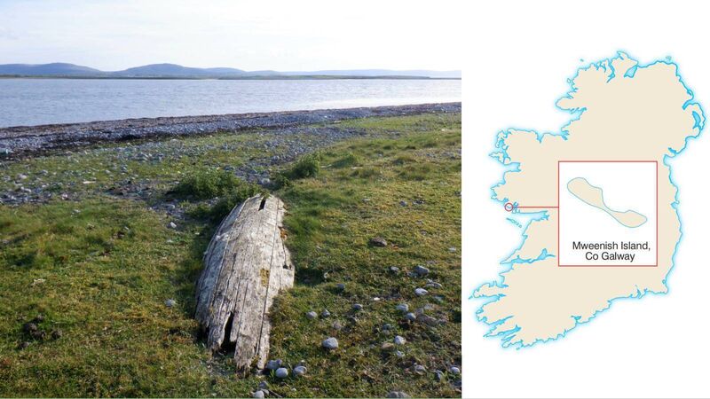
For such a complex of shifting landscapes and seascapes including small bays, reefs, sandbars, and plenty of islands it is a wonder that the area was mapped so efficiently by French cartographers in the 17th century. Of course, the country was under British rule then, but certain French seafarers/ pirates ‘bent on trade or warfare’ had reason to have their own maps. Mweenish Island is mentioned as a safe place to go ashore if a ship was in need of repairs. Today, there is very little evidence of human agency on Mweenish Island though the upturned ruin of a currach points at once to the romance and the danger of that way of life.

Currach ruin on Mweenish Island, County Galway. Picture: Dan MacCarthy

Mweenish Island was also used for gathering seaweed which was an important part of the local economy. An extensive area of ‘mearings’ or ‘seaweed rights’ was marked out by stones which distinguished the right to collect seaweed in a given area. Mweenish had one such area while Island Eddy to the south had about 10, and the coastline north of Mweenish dozens more. The authors of the report below indicate that the seaweed in this case was used for manure and not kelp production.

There is another Mweenish Island along the County Galway coast near Carna. The word comes from the Irish Maínis, possibly derived from Minish (lake) or Muíghnish, ‘island of the plain’. A third interpretation is ‘soft island’.

Mweenish is a lovely island for a stroll and there is even a path on the southern side suggesting occasional use. If you are sure of the tides and safe in the knowledge that your boat won’t be marooned in a sea of mud, you can relax and revel in the antics of the frolicsome terns and audacious oystercatchers.

How to get there: Kayak about 2km due west from Killeenaran Pier, Clarinbridge, County Galway.

Other: Jane Conroy, Journal of the Galway Archaeological and Historical Society, volume 49 (1997); Journal of Irish Archaeology, 2014, volume 22

More in this section

Revoiced

Newsletter

Sign up to the best reads of the week from irishexaminer.com selected just for you.

Cookie Policy Privacy Policy Brand Safety FAQ Help Contact Us Terms and Conditions

© Examiner Echo Group Limited