Orange rain warnings issued as flooding risk rises across south-east and east

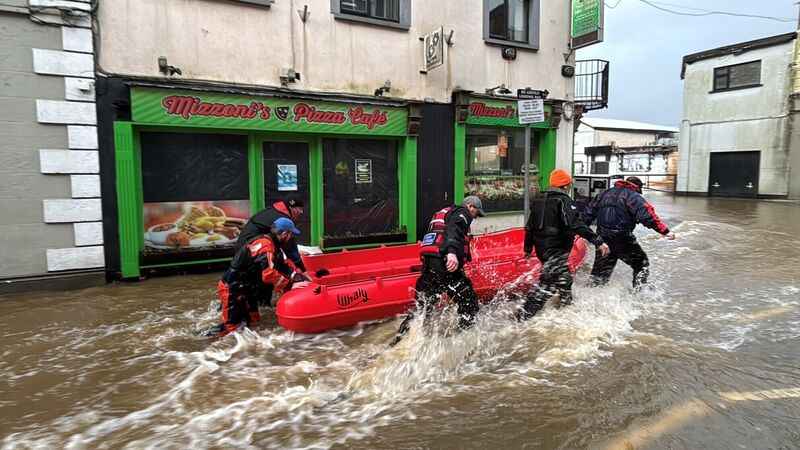
Members of Slaney Search and Rescue working in floodwater in Enniscorthy last week. Picture: Niall Carson/PA Wire
Spells of very heavy rain are forecast to hit the south-east and east of Ireland, with Met Éireann issuing status orange and yellow warnings as significant rainfall is expected in areas already affected by flooding in recent days.
Met Éireann has issued two status orange rain warnings for Waterford and Wicklow, both coming into effect at 3am on Thursday and remaining in place for 24 hours.
"Spells of very heavy rain falling on already saturated ground combined with high river levels and high tides will lead to: localised flooding, river flooding, and difficult travel conditions," the forecaster warned.
A status yellow rain warning will also be in place for Tipperary, Carlow, Dublin, Kildare, Kilkenny, Laois, Louth, Wexford, and Monaghan from 3am on Thursday until 3am on Friday.
The National Emergency Co-ordination Group said local authorities and other response agencies have received briefings, are monitoring risks, and stand ready to take action to protect communities.
"Already, they have been deploying and replenishing sandbags, clearing drains and carrying out other flood prevention works. Local authority Severe Weather Assessment Teams are continuing to meet to assess the situation and respond, as needed, to protect communities," it said.,
National Directorate for Fire and Emergency Management director Keith Leonard said earlier that agencies are taking every possible measure to deal with flooding.
Speaking on RTÉ’s , he said: “Every engineering solution and every kind of interim measure that can be taken is being taken to try and just deal with this, really almost record breaking levels of water.
“(This) is going to be a key time, probably late tomorrow evening into Friday morning.
“That’s going to be when local authorities are on the highest alert for what's happening.”
Mr Leonard said that although there has been a “moderate amount of rainfall and some flooding in areas” and “nothing significant” in the last 24 hours, difficult conditions will return across the eastern region on Thursday.
He said the main areas of concern include the catchments of rivers such as the Slaney and the Liffey, which will reach “very high levels right across this evening and into tomorrow.” While he said it remains too early to predict further flooding events, the country is now in “a very unusual situation.”
He said: “Rainfall below the warning thresholds (is having) an impact across the rivers, and sometimes the rainfall, the impact lags behind the rainfall.
“So you could have impacts right up until Friday, right across that but again, even Cavan Monahan, any part of the East region now could be affected.”
He said councils less affected by recent weather are sharing resources with those under greater pressure.
“You would have seen the movement of an aqua dam into Enniscorthy yesterday,” he said.
“Likewise, in Carlow, there's been significant pumping operations in areas where there are known vulnerabilities from flooding.
“So every engineering solution and every kind of interim measure that can be taken is being taken to try and just deal with this.”
Meanwhile, Met Éireann has also issued a nationwide weather advisory in place until Monday.
The forecaster said “spells of heavy and persistent rainfall” will continue through the week, particularly across southern and eastern counties.
It also warned that flooding is likely due to saturated ground, high river levels, and high tides.
Met Éireann has urged close monitoring of local weather conditions.
CLIMATE & SUSTAINABILITY HUB


