Storm Éowyn: All schools to close as status red warnings extended to entire country 
Storm Éowyn: All schools to close as status red warnings extended to entire country 

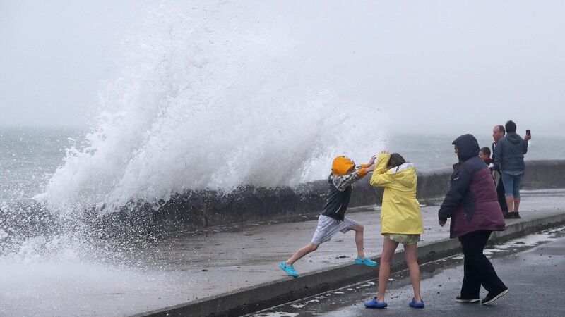
People are hit by waves on the Front Strand in Youghal, Co. Cork. Picture: Niall Carson/PA Wire

The whole country will be under a status red "danger to life" warning on Friday as Storm Éowyn is set to bring "severe, damaging, and destructive winds".

The storm is set to hit the country in the early hours of Friday morning and could be one of the most severe storms ever to hit Ireland. 

Status red wind warnings have been issued for: 

  • Cork, Kerry, Limerick, Carlow, Kilkenny, Wexford and Waterford, with the warning coming into effect from 2am to 10am on Friday;
  • Clare and Galway, with the warning coming into effect from 3am to 12pm;
  • Leitrim, Mayo and Sligo, with the warning coming into effect from 4am to 12pm;
  • Donegal, with the warning coming into effect from 6am to 3pm;
  • Cavan, Monaghan, Dublin, Kildare, Laois, Longford, Louth, Meath, Offaly, Westmeath, Wicklow, Roscommon and Tipperary with the warning coming into effect from 6am to 12pm.

"Gale-force southerly winds becoming westerly will bring severe, damaging, and destructive gusts in excess of 130km/h," Met Éireann warned.

Schools, childcare facilities, and higher education institutions in red warning areas will close during the alert. Employers should facilitate remote working, and only emergency workers should travel for work.

A Department of Education spokesperson said all schools "should keep up to date with the current weather warnings which are carried on all national and local news bulletins and in particular any change in the status warning for their area" and remain vigilant, and advised those in affected areas to "keep themselves apprised of any hourly and other updates from Met Éireann, and from their local authorities".

Public transport will not operate in red warning areas until conditions improve.

The National Emergency Co-ordination Group (NECG) has advised people in red warning areas to "stay indoors, avoid unnecessary travel, and take action to protect themselves and their properties."

Potential impacts

Potential impacts of the storm in the counties affected by the red warnings include:

  • Danger to life; 
  • Extremely hazardous travelling conditions; 
  • Event cancellations; 
  • Wave overtopping; 
  • Coastal flooding in low-lying and exposed areas; 
  • Unsafe working conditions; 
  • Fallen trees; 
  • Significant and widespread power outages; 
  • Structural damage; 
  • Transport disruption and cancellations. 

In addition, a status orange wind warning for the entire country will be in place from 2am to 5am on Friday.

A status yellow rain warning for Cork, Kerry, and Waterford will take effect at 9pm on Thursday and remain in place until 9am Friday. Met Éireann has cautioned that heavy rain may cause localised flooding.

The National Emergency Co-ordination Group (NECG), which met this afternoon ahead of the storm, has warned that additional counties may be upgraded to a red warning before the storm arrives.

The NECG advises residents in red warning areas to "stay indoors, avoid unnecessary travel, and take action to protect themselves and their properties."

Keith Leonard, chair of the NECG, said: “Storm Éowyn is going to be a very dangerous and destructive weather event. The forecasted winds have the capacity to bring severe, damaging winds which will constitute a risk to life and property.

"During the red level wind warnings, the public are advised to shelter in place.

Met Éireann says gale-force southerly winds becoming westerly will bring 'gusts of up to 130 km/h widely, with even higher gusts for a time'. Picture: Denis Minihane.

“Where orange warnings are in place, the public are also advised to limit travel to essential journeys only. 

"An orange wind warning should not be underestimated – it can bring extremely strong gusts and can also pose a threat to life and property.

“I would urge people to stay away from coastal areas during this period and to heed the appeal from the Irish Coast Guard for people to ‘Stay Back, Stay High, Stay Dry’.

"It’s also important to remember that even after the storm has passed, there is a strong possibility of fallen trees and other debris so drivers are also urged to take care in the aftermath of the storm.”

The NECG will continue to liaise with Met Éireann and monitor the situation.

Local Authority Severe Weather Assessment Teams will also monitor conditions locally, and emergency response teams will be in place.

Storm Éowyn is the fifth named storm of the season, as per the storm names list for 2024/2025.

Ahead of the storm, Met Éireann issued a weather advisory for the whole country, stating:

"On Thursday night and Friday, a deepening low-pressure system, Storm Éowyn, is forecast to track across Ireland.

"Very strong to gale-force winds are expected nationwide, with the potential for damaging gusts and disruption in places.

"Transitory falls of sleet and snow are also expected, particularly in western and northwestern counties. High seas and heavy rain are anticipated as well."

Met Éireann is closely monitoring the "evolving situation." 

The advisory is valid until midnight on Saturday.

A status orange wind warning for the entire country will be in place from 2am to 5am on Friday. File photo

Alan O'Reilly of Carlow Weather remarked that the storm could rival Storm Ophelia in 2017.

"This looks like the most significant storm I've seen on weather forecasting models since probably Ophelia," Mr O'Reilly said.

"I'm not saying it will be as bad for all areas, but it could be.

"There’s a possibility it could be close, particularly where the strongest winds hit the southwest or west.

"Since the storm hasn’t fully developed yet, the exact track may change. Met Éireann will likely issue updates and possibly upgrade warnings."

Cork County Council says its Severe Weather Assessment Team convened on Wednesday afternoon to plan for the upcoming "severe and destructive storm".

 A council spokesperson said crews had been deployed to inspect "key high-risk areas and will continue to monitor the situation throughout the period".

"Pumping arrangements will be in place in known problem locations," the spokesperson added.

Midweek Weather Outlook 

On Wednesday, "lingering mist and fog will clear from most areas," though it may persist in parts of the north and northeast. Most of the country will remain dry, with a "mix of cloud and sunny spells" and isolated light showers. Highs of 4 to 9 are expected, with colder temperatures where fog lingers.

Overnight, conditions will be "rather cold," with areas of fog and a "slight frost."

Thursday will be breezy, with a "band of squally and possibly thundery rain" moving eastward in the morning. Sunny spells and heavy showers, some with hail and isolated thunderstorms, will follow.

x

Check out the Irish Examiner's WEATHER CENTRE for regularly updated short and long range forecasts wherever you are.

More in this section

Lunchtime News

Newsletter

Keep up with stories of the day with our lunchtime news wrap and important breaking news alerts.

Cookie Policy Privacy Policy Brand Safety FAQ Help Contact Us Terms and Conditions

© Examiner Echo Group Limited