Island of Ireland: The conundrum of this Kerry island
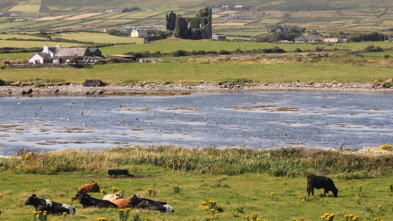
Dan MacCarthy visited Foughil Island in Co Kerry which is defined by what it hasn't, rather than what it has
Island of Ireland: The conundrum of this Kerry island

Foughil Island, Caherciveen, Co Kerry. Picture: Dan MacCarthy

As the Bard of Avon wrote in Macbeth... this is a Co Kerry island defined by what it hasn’t, rather than what it has and thus captures the paradox. Foughill's neighbours have an embarrassment of riches but it itself has very little to bring to the table. Foughil Island lies just off Caherciveen in the estuaries of the River Ferta and the River Carhan which flow into the sea from the east and the south of the town of this magnificent spot on the southwestern seaboard.

A few kilometres landward is Reenard Point which is connected to Valentia Island by car ferry and which knocks off a good 20km for those driving to the island.

The oddly-shaped Beginish Island lies between the town and Valentia Island and has the ruins of a Viking house which is just one of the pearls in its box of treasures. Church Island is just off the east end of Beginish and boasts a monastery including oratory, hut, holy well and a shrine which were constructed there in the seventh century. Much of the complex is still intact today and makes for an amazing trip not just for students of church history. Even the fourth of the quartet, Lamb’s Island at the mouth of Valentia Harbour, though it also has nothing much to report, has more appeal than Foughil because of its location facing out to sea.

Dan MacCarthy: 'What is likely to have prevented the island being inhabited is its marshy nature and the risk of flooding as it is so low-lying'

Poor Foughil doesn’t even have elevation going for it. Beginish rises to a comparatively mighty 64m; Church Island appears high because it has no foreshore, though it has only 5m; Lamb’s Island boasts 14m of height. Foughil, as an estuary island formed over thousands of years by deposits from the rivers has just 3m of elevation in its expansive 15 acres.

The archaeological record shows nothing there: not a ringfort, or a standing stone or a souterrain. In an area with an incredibly rich hinterland of archaeological monuments there is nothing recorded for Foughil Island. It’s as though the slate has been wiped clean. Access for historic currachs would have been no problem. It is a conundrum. The immaculate stone ringfort at Cahergall 1km to the north teases with possibilities.

What is likely to have prevented the island being inhabited is its marshy nature and the risk of flooding as it is so low-lying. Foughill Island is the centrepoint of a trigonometrical point defined by the hills of Beentee to the south, Castlequin to the north, and Killeland Mountain to the west which slopes down to the sea at Doulus Head.

Nowadays, cattle loll in the fields, chewing the cud, minding their own business. The island is divided into several large fields but there is nothing evident of ruins or an old road that might suggest former occupants. Today, the only occupants, other than the bovine ones, are the plentiful species of waders that forage in the surrounding mudbanks, including godwits, whimbrels and oystercatchers.

A clue to Foughil’s possible importance comes with its name. Of the five spellings given at logainm.ie the derivation of one jumps out: ‘Fochoill' or ‘underwood’. The other names recorded for Foughill over the centuries are: ffogholl; Foghill; Fochoille; Fo-choill. All have an element of ‘choill' or ‘wood’.

It is possible that the island, if heavily wooded, was used as a resource by the MacCarthy Mórs who are regarded as having been the occupants of the adjacent Ballycarbery Castle. Wood would have been in demand for use in construction of houses, carts and boats, and manifold other functions. The standout feature, manmade or natural, in the vicinity of the island is this imposing ruin which was the seat of power of the MacCarthy Mórs in the 16th century. The castle was later bombarded by Cromwell’s forces and Foughill Island would have served as a perfect vantage point to have carried out that attack.

On the northwestern shore is Laght Point with the gorgeous White Strand around its tip. Opposite Foughill is Mannix Point and its campsite. Yachts berthed at Caherciveen’s handsome Marina will sail past Foughil but very few passengers will disembark or cast a second glance.

More in this section

Revoiced

Newsletter

Sign up to the best reads of the week from irishexaminer.com selected just for you.

Cookie Policy Privacy Policy Brand Safety FAQ Help Contact Us Terms and Conditions

© Examiner Echo Group Limited