Storm Amy: 107mm of rain falls on Glengarriff as fresh orange and yellow weather warnings issued
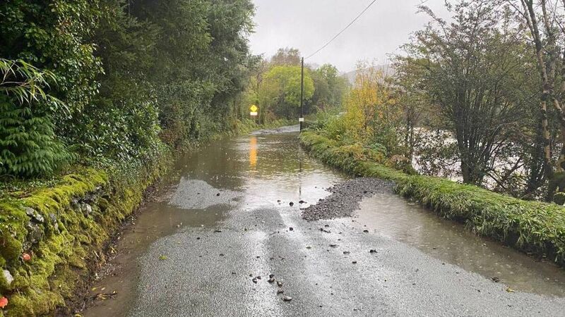
Flooding by the River Ilen in West Cork on Thursday afternoon. Picture: Cork County Council/Facebook
The effects of Storm Amy, the first named storm of the new storm season, are beginning to be felt here, with flooding already reported in the west of the country, and more than 100 millimetres of rain recorded in Glengrariff, West Cork, on Thursday.
According to Met Éireann, some 107mm of rain has fallen on the West Cork village over a 22-hour period, leading to significant flooding and road closures in the area.
Result of that rain in West Cork at Borlin Valley with road badly damaged and flooding. Glengarriff recorded 107mm since midnight. pic.twitter.com/S33O8oTec1
— Carlow Weather (@CarlowWeather) October 2, 2025
On Thursday afternoon, flooding saw Cork County Council close the N71 Tunnel Road at the church, though the road was passable once again shortly before 8pm.
Elsewhere in West Cork, heavy rains caused the River Ilen to burst its banks, leading to the closure of the R594 at Madore. Flooding was also reported at Coomhola, and along the R587 at Arcahan Bridge, both of which remain closed to traffic.
Multiple status orange and status yellow warnings have been issued by Met Éireann for Friday, when the worst of Storm Amy is expected..
Donegal, Galway, Leitrim, Mayo, and Sligo will all be under a status orange wind warning from 2pm, with "near gale force to gale force and very gusty southwest to west winds" forecast before the warning ultimately lifts at 10pm.
Met Éireann is also warning of fallen trees, damage to power lines and possible power outages, wave overtopping, and very difficult travelling conditions in these counties.
From 9am until 3pm tomorrow, Galway and Kerry will be under a status yellow rain warning, with more flooding and difficult travelling forecast.
Finally, the entire country will fall under a status yellow wind warning from midday, with Met Éireann predicting strong to near gale force and gusty southwesterly winds, amid generally difficult travelling conditions, and the possibility of fallen trees.

Earlier on Thursday afternoon, the National Directorate for Fire and Emergency Management (NDFEM), Met Éireann, and representatives of other relevant agencies met to discuss the weather warnings.
NDFEM national director Keith Leonard said it was "quite clear that we will have challenging weather conditions at local level in many counties" in the days ahead.
Mr Leonard said Local Authority severe weather teams had been activated and are preparing for the storm’s approach.
“For those in areas affected, I would advise they pay attention to their local conditions and members of the public should monitor Met Éireann’s ongoing advice and act accordingly," he said.
"Even after the storm has passed, there is a possibility of road flooding or fallen trees so drivers are urged to take care in the aftermath of the storm."
Mr Leonard urged members of the public to stay away from coastal areas during the storm and to" heed the appeal from the Irish Coast Guard for people to ‘Stay Back, Stay High, Stay Dry'."
#WarningUpdates for Friday 3rd October and Saturday 4th October.
— Met Éireann (@MetEireann) October 2, 2025
Previous warnings remain valid and are available on our website.
Please keep up to date on our website👇 https://t.co/w5QtJ1V6un#StormAmy pic.twitter.com/sYGmhHefwD
Speaking about Storm Amy, meteorologist Ailís Hankinson said: "It is the first storm of the season, so it’s essential to be prepared for potential impacts caused by the strong winds and the rain. There could be difficult travelling conditions, loose objects or flying debris.
"Trees are still in leaf at this time of the year, so there could be higher impacts from fallen trees and leaves blocking drains, causing localised flooding. Small, upland river catchments are the most at risk of flooding, so precautions for potential localised flooding in these areas are also important."
The forecaster says the warnings are likely to be updated “as certainty increases," noting that the wind warnings could be extended into Saturday for parts of the north west.
Impacts of the storm will include:
- , the heavy rain will fall on already saturated grounds, with river levels increasing. Smaller upland catchments in the South-West and West are at the greatest risk of flooding, as mountainous areas are currently forecasted to see the greater rainfall accumulations.
- , as the ground is saturated countrywide. Trees are in leaf at the moment so fallen leaves and other debris may block drains and small rivers, increasing the risk of surface water flooding.
-
: even if we’re in a period of neap tides, strong onshore winds and significant waves from Storm Amy may cause isolated spray overtopping at times of high tide along the West coast.
Check out the Irish Examiner's WEATHER CENTRE for regularly updated short and long range forecasts wherever you are.