The best of the Wild Atlantic Way
NINE counties, three provinces, over 50 Blue Flag beaches, 50 loop walks, 120 golf courses, 160 discovery points, 3,850 signs, over 1,500 miles â thatâs the Wild Atlantic Way for you.
If you have the time, the patience, the sense of adventure, the money and the weather, then youâll have the same kind of blast you experience as you see (and feel) waves crashing into the Cliffs of Moher.
From Malin Head (Irelandâs most northerly point) to Mizen Head (Irelandâs most southerly point) and traversing along the Westward way via Buncrana, Mullaghmore Head, Connemara, the Burren, Cliffs of Moher, Dingle, Dursey Island and West Cork, the WAW is a marketerâs dream that has been finally realised.
Focusing on a specific organised route that takes in all the sights that tourists had up to now randomly admired and visited, the route also takes out the problematic issues of where to go and what to do over a five day period of time.

The appeal to people from urban areas is undeniable: Ireland has, believe it or not, beaches that can compete with stretches in Australia and America.
Ireland has all the rolling hills and valleys (âOut of dreams, with white smoke coming from distant chimneys and herds of sheep littering the pastures,â extols The Huffington Post) anyone needs.
Pitched as the worldâs longest defined coastal driving route, the WAW has had over âŹ10m thrown at it â new navigator-friendly signposting, upgrading visitor attractions â and already the marketing machine has kicked in, with major tour operators in America, UK, France and Germany knee-deep in organising the visits of tens of thousands of tourists.
With all of this in mind, itâs impossible to cover everything that the WAW has to offer in terms of visitor attractions and sights.
For every remote hideaway (and there are many), there are small towns and big villages just waiting to be explored.
Some will take a few hours, others less than 60 minutes, but everything you see and experience will bear the singular hallmark of Ireland. What follows, then, is just a primer.

Beginning north in the Donegal region, remember that here is where youâll get the occasional opportunity to view the Northern Lights whenever they come out to dazzle.
We recall a year or two ago when the sky was virtually kaleidoscopic, such was the atmospheric and electric intensity of the skies.
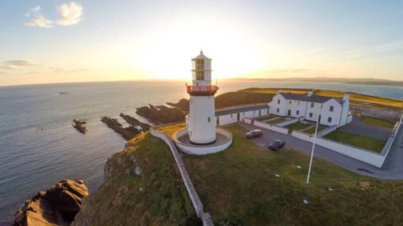
Staying in the Donegal area, make your way to Fanad Head, which is home not only to a lighthouse, but also Ballymastocker Bay, whose Blue Flag beach has delighted lovers of the kind of sandy stretches you usually see belonging to islands in the Indian Ocean.
Downwards into Sligo and the perennially stunning Ben Bulben mountain, the plateau of which acts as a table top by which you see all around you some of the most beautiful countryside in the world.
Sligoâs famous headland, Mullaghmore, has latterly become something of a magnet for surfer communities, which arrive here to âcatchâ the surging 100ft waves.
If youâre Connemara-bound, then make sure you drive around Killary Harbour, which is one of three glacial fjords in the country.
Framed by awe-inspiring mountain peaks and the kind of rugged coastal scenery that is both a balm to the soul (if youâre relaxing) and a jolt to the system (if youâre participating), donât forget to stop off in the village of Leenane, which hasnât really changed since God made little green apples.

If youâre after a spot of urban life (but not too much â you donât want to spoil the overall experience, do you?), then head to either Clifden or Westport. Each small town has leg-stretching main streets with extremely good restaurants and pubs.
Down to Clare, and itâs a visit to the Cliffs of Moher. If there is one stop-off on your journey that reminds you why the route has been termed the âWildâ Atlantic Way, then the Cliffs of Moher is it.
Over 8km of sheer cliff face will look you in the eye and pronounce you a coward for flinching at the wind, the surging waves, and the rain-spittle.
Onwards towards the Blasket Islands, which lay off the coast of Kerry at a point that is actually, truly, the very edge of Europe.
There is a Blasket Visitor Centre, Dunquin, which is exceptionally moving and evocative, as it details how the islanders once lived.
A short enough drive (once youâre on dry land, that is!) will bring you to Dingle (and its peninsula), and if thereâs a prettier town in all of Ireland then we have yet to visit it.
During December, the town is home to the Other Voices music festival, but during the summer, winter is the last thing on its mind; here is a thriving small community, very much its own boss, that is as welcoming as a smile.

Continuing south, youâll no doubt venture to Dursey Island, which is Irelandâs most westerly inhabited island (it is home to three farming families).
Here, you can access the island via a cable car service. Word of advice â please wear boots, as sheep and cattle use the cable car service, too.
Our final WAW stop (and a personal favourite) is Kinsale, which is the cherry on top for anyone who loves gourmet food.
Letâs face it, after negotiating all the way from Donegal to here you deserve a treat, donât you?
Asking anyone to recommend either restaurants or pubs along the WAW is dangerous, but we are made of stern stuff, so here goes.
The recommended restaurant is The Pantry & Corkscrew, The Octagon, Westport ( www.thepantryandcorkscrew.com ), which (overseen by husband and wife team, Dermott Flynn and Janice OâRourke) has been in operation for over five years.
Local quality produce cooked with a Slow Food ethos makes P&C one of our WAW favourites. The recommended pub is Dick Macks, Green Street, Dingle, as singular a place to have a pint as any youâll have been in.
If you want somewhere very special and different that is tucked away (but which is within mere minutes reach of a beautiful small town) then check into the unique Dromquinna Manor ( www.dromquinnamanor.com ), which offers luxurious camping facilities, left, as well as dedicated Motorhome pitches. Kenmare is nearby, so if you get lonely thereâs some hustle and bustle there.
The Wild Atlantic Way signage is very similar to a horizontal zigzag line. The roads along the WAW are mostly rural, so we canât see you doing more than 65km per hour.
We say this because you will occasionally encounter slow tractors, passing cattle and sleeping sheep.
And speaking of driving, when your fuel tank dips below the halfway mark top up at the nearest filling station â the WAW is not Route 66.
Layers. Lots of layers. Believe me, the sun will not shine more than an hour at a time.
CONNECT WITH US TODAY
Be the first to know the latest news and updates