Monument believed to be the grave of a wealthy landowner who wanted to be buried upright
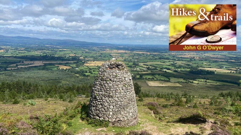
The Grubb Monument. Pictures: John G O'Dwyer
Just beyond the horseshoe bend that defines the Vee Gap in the Knockmealdown Mountains, motorists will observe a 'strange to behold' edifice above the road.
Generations of children have been informed that this beehive-shaped monument, built from rubble stone, is the last resting place of Samuel Grubb. From a local Quaker family, he was an extensive landowner, whose final request was not to be interred in a graveyard, but high on the slopes of Sugarloaf Mountain.
The Religious Society of Friends (Quakers) was founded in England during the mid-17th century, with its members known for their strong commitment to peace, equality and toleration. In a time of inequality, intolerance and religious conflict, the Quakers were commonly persecuted for their non-conformist beliefs. They were excluded from public office and the professions because they refused to make an oath of allegiance to the English monarch. With their opportunities for progress restricted in this way, many set up businesses that were hugely successful due to their strong work ethic and minimalist lifestyles.
While always a tiny minority of the population, the Quakers made a disproportionately positive contribution when they arrived to Ireland. Families such as Bewleys, Jacobs, Lambs, and Goodbodys gave their names to successful businesses that survive to this day. With philanthropy as a core value, these and other Quaker families hold a special place in Irish history, being among the first to respond to the Great Famine by establishing soup kitchens nationwide.

In Tipperary, the best-known Quakers were the Grubbs; this family set up several milling businesses in South Tipperary.
One branch established itself near the village of Clogheen at the beginning of the 19th century. Building a large flour mill powered by water wheels, they created valuable local employment at a time of grinding poverty in rural Ireland. The mill prospered for a time, with the product being exported by the River Suir from Clonmel.
In the end, it was the repeal of the Corn Laws in 1846 — ironically in response to the Great Irish Famine — that signalled a rapid decline for Ireland’s milling industry. Cheap corn from the US flooded the British market, with Irish flour producers unable to compete. The result was that the Clogheen mill closed along with many others, but the Grubbs continued to prosper as extensive landowners in the area.

In the latter part of the 19th century, more than 1,600 acres of the best Tipperary land at Castlegrace was owned by Samuel Grubb. Very much part of the establishment, he was a Justice of the Peace and later High Sheriff of County Tipperary — roles that would have been denied to his ancestors.
Passing away in September 1921, he was interred at his request on the Knockmealdown Mountains. Local tradition holds that he also wished to be buried in an upright position to keep an eye from the grave on his extensive estates in the valley below. Whether this is the actual reason for his upright position, and not the practical difficulty of digging and securing a grave in the rocky unforgiving mountainside, is impossible to ascertain.
What is certain, however, is that Grubb's final resting place on Sugarloaf Mountain a is now a much-visited landmark in the Knockmealdown Mountains offering splendid views over the Tipperary countryside laid out below.
If you wish to visit Grubb's Grave, park beside the R688 on the Lismore side of the Vee hairpin bend. Here, it is an ascent of about 150 metres along a rough, stony path to his beehive-shaped resting place.
For those with time to spare, a much nicer option is to follow the Vee Valley Loop, which takes about three hours to complete. Traversing woodlands, wetlands, moorlands and a lovely lakeside, this nine-kilometre walk offers stunning views and is entirely off-road and fully waymarked.
From Killballyboy Wood Car Park (S, 01970 12339) follow the purple arrows east through natural woodland, cross a pretty footbridge and enter Bohanagore forest. Go left, and follow the arrows to eventually leave the woodlands and cross through bogland.
Beyond, a rough path ascends to gain the Grubb Monument, which makes a nice place to take a break and enjoy the panoramic view.
Continue to where the path descends to cross the busy R668 and then meander downhill to reach storied Bay Lough.
This corrie lake is reputed to be the domain of local witch Petticoat Loose. Tradition holds that her ghost terrified people in the local area until she was banished into this watery abode by a local priest. Ghost or not, the lakeside makes a pleasant place to tarry awhile.
Then, conclude your day with a descent of what is known locally as the Soldier's Road, before swinging right to regain your start point at Killballyboy.
- The latest edition of John G O'Dwyer book, , (Currach Books) is out now