Islands of Ireland: Crumbling castle on the island with no name
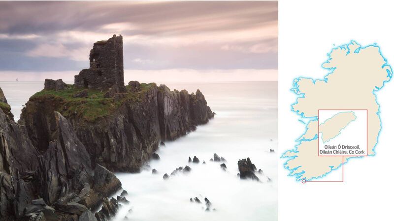
Dún an Óir tower house on Cork's Oileán Chléire is unlikely to survive longterm — but would have once been a commanding sight to approaching ships
Islands of Ireland: Crumbling castle on the island with no name

Islands of Ireland: Oileán Ó Drisceoil, Oileán Chléire, Cork

Of all our spectacularly sited castles or tower houses (Carrigadrohid on the River Lee, the Rock of Cashel in Co Tipperary) Dún an Óir is possibly the cream of the crop. It was built in the mid-16th century on a small promontory but the intervening centuries have seen it cut off from the island of Oileán Chléire.

It is an island with no name but an island it is nonetheless. And while there are many unnamed islands and islets scattered around the country, this one has a significant historical charge in that the ruins of the castle are perched on top — alas crumbling into the sea with each storm that tears through.

A recent report by Dr Sarah Kerr of Trinity College Dublin underlines its precarious survival chances: “This once strategic position is Dún an Óir’s Achilles heel. The building and its immediate landscape are precarious, unconsolidated and unprotected. Exposed on a partially collapsed promontory, its long-term survival is unlikely.”

The Gaeltacht island of Oileán Chléire, or Cape Clear, is possibly Ireland’s best-known island after the Aran Islands. It has a few satellite islands: Illauneana; Illaunnagart and this, unnamed island. At two roods — 12 perches in old money, or about half an acre in new — its diminutive size made it perfect for its raison d’etre: Difficult to reach.

Located in the Oileán Chléire townland of Baile Iarthach Thuaidh, or Ballyieragh North, it is one of 11 castles of the O’Driscoll clan constructed in the 16th century which dominated the West Cork coastline. Other significant castles of the clan were located at Sherkin Island, Baltimore, and Ringarogy. Dún an Óir (“fort of gold”, anglicised to “Doonanore”), was the seat of O’Driscoll power on Oileán Chléire. It was principally used as a base to receive payments from ships that sailed in the waters of Roaringwater Bay, in effect a rudimentary customs operation. It formed a significant share of the clan’s takings.

The ruin was once a much larger structure of four storeys and would have been a commanding sight to approaching ships. Archaeology.ie states that “much of the ground floor is filled with fallen rubble”. The third floor had pointed arches, and other features included a garderobe (bed chamber or store room for valuables) and a bread oven. A bawn (low wall) stretches westward to partially enclose the rest of the island.

Archaeology.ie, citing the antiquarian Thomas Westropp, states that the castle may have been built on top of a much earlier promontory fort of which there are other examples on Oileán Chléire. Its record states that the “promontory is now isolated at high tide but was connected to mainland by causeway until 1831”.

The battering of the island by the unrelenting Atlantic saw further erosion of the link to Oileán Chléire until another study 30 years later reaffirmed its separation. According to the Geological Survey of Ireland of 1861.

“A little on the west of the north harbour there is a ruin of a castle called Doonanore, which shows the encroachment of the sea during the historical ages. Smith in his History of Cork, written in 1750, mentions that ‘there is a very narrow passage about a yard broad, and ten yards in length, leading to the castle’. Now this passage is nearly all gone, and only half of the castle remains, as the other half was carried away with the rock on which it was built.”

The predominant placename here is for a reef called Tóin Loinge or Tonelunga (also given as Tonelurga on the Ordnance Survey maps) which translates as “bottom of the ships” which suggests the site was the scene of many a shipwreck. That would be unsurprising given the jagged nature of the rocks there. However, no record of shipwrecks is shown on the national monuments record at archaeology.ie. An alternative interpretation of Tóin Loinge is the place at the bottom of the cliffs where ships gathered, in reference to the O’Driscoll ships and those paying duties.

As for suggesting a name for the island: That would have to be Oileán Ó Drisceoil.

How to get there: Ferry from Baltimore or Schull to Oileán Chléire. Doonanore is a 10-minute walk from the pier in a northwesterly direction

Other: castlestudiestrust.org, Archaeology.ie

x

More in this section

Revoiced

Newsletter

Sign up to the best reads of the week from irishexaminer.com selected just for you.

Cookie Policy Privacy Policy Brand Safety FAQ Help Contact Us Terms and Conditions

© Examiner Echo Group Limited