New yellow rain warnings issued as flooding risk persists after Storm Chandra
New yellow rain warnings issued as flooding risk persists after Storm Chandra

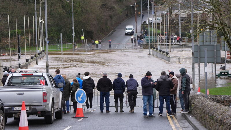
People watching the banks of the River Slaney flood in Enniscorthy, Co. Wexford. Picture: Niall Carson/PA Wire

New Status Yellow rain warnings remain in place for parts of the east and southeast, with Met Éireann warning that further heavy rain on saturated ground could lead to renewed flooding and travel disruption.

A yellow rain warning is currently in effect for Carlow, Dublin, Kilkenny, Wexford, Wicklow and Waterford, having come into force at midnight and remaining valid until midnight tonight.

A subsequent yellow rain warning has also been issued for the same counties, along with Louth, which will take effect at 9am on Friday and run through until midnight.

Met Éireann said heavy rain falling on already saturated ground, combined with high river levels, could cause localised flooding, river flooding and difficult travel conditions.

A burst water main in the Fairview area of Dublin added to weather-related commuter disruption in the capital, while subsidence sent a tree onto the Dart rail route near Portmarnock, temporarily closing services between Portmarnock and Howth Junction. The line, which also affected services to Belfast, has since reopened.

The renewed warnings come after Storm Chandra caused widespread disruption across the island earlier this week, including power outages, flight cancellations and the closure of around 300 schools in Northern Ireland.

Rivers burst their banks, including the Slaney in Co Wexford and the Dodder in Dublin, while fallen trees were reported nationwide. At the height of the storm, up to 20,000 properties were without power.

The scale of flooding in some areas has increased pressure on Met Éireann and the Government over whether weather warnings were sufficient, with concerns that further rainfall on Thursday could worsen conditions.

Met Éireann forecaster Holly O’Neill said the greatest risk of localised flooding remains in parts of Munster and Leinster.

“Because of the ground situation at the moment, the grounds being so saturated and with the rivers being so high, any further amount of rainfall that we are going to get is going to have a greater impact than that amount of rainfall would normally have on any other day,” she told RTÉ’s Morning Ireland.

“It's just because that rain has nowhere to go, basically. So, even if it is only as small as 5mm [of rain that] we see today, it will likely have a greater impact than it would on any other day.” 

Union calls for climate leave 

As clean-up efforts continue, the trade union Unite has renewed calls for the introduction of paid climate leave when extreme weather makes it impossible for workers to travel.

The union is seeking four days’ paid leave where extreme weather prevents attendance at work, and a further four days where workers need to deal with damage to their homes.

Unite is also calling for a legal obligation on employers to introduce alert-based responses, including stopping non-essential outdoor work during amber warnings and all non-essential work during red alerts, with workers paid as normal.

Additional proposals include a 24C “action level” for heat management controls and an absolute maximum working temperature of 30C where risks cannot be mitigated.

Unite Irish secretary Susan Fitzgerald said health and safety legislation must be updated to reflect the growing impacts of climate change.

Irish Congress of Trade Unions president Phil Ní Sheaghdha said workers should not be penalised for extreme weather events.

“When storms strike, many workers are advised to work from home where possible.

“But many others can’t work from home, either because their employer can’t or won’t facilitate that or because they are essential workers.

“All employers must be compelled to prioritise staff safety and ensure that workers do not pay the price, financially or in terms of their wellbeing, for extreme weather events.” 

Rail disruption 

Iarnród Éireann said services were disrupted after subsidence occurred on the line between Portmarnock and Malahide, while flooding north of the border also affected the Belfast line. 

Limited bus substitutions were put in place, with passengers advised to check services before travelling.

Crews have been working to repair damage to signalling equipment in Enniscorthy, with a full service expected to resume later.

More rain ahead 

Thursday will begin cloudy with scattered outbreaks of rain, before more persistent rain moves into the southwest and spreads northeastwards, turning heavy in places.

Further rain will continue overnight, easing gradually, while Friday will bring additional spells of rain, with saturated ground maintaining the risk of localised flooding.

Rain will become lighter on Friday night, with temperatures falling to between 1C and 4C, and frost and ice possible.

Conditions are expected to gradually improve over the weekend, though further outbreaks of rain are forecast into early next week.

Check out the Irish Examiner's WEATHER CENTRE for regularly updated short and long range forecasts wherever you are.

More in this section

Lunchtime News

Newsletter

Keep up with stories of the day with our lunchtime news wrap and important breaking news alerts.

Cookie Policy Privacy Policy Brand Safety FAQ Help Contact Us Terms and Conditions

© Examiner Echo Group Limited