Snow blankets parts of Ireland as Met Éireann issues nationwide ice warning
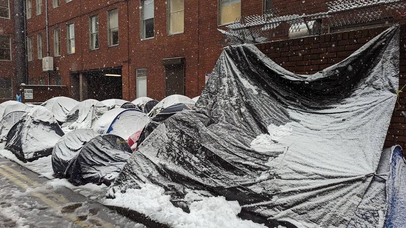
Snow blankets parts of Ireland as Met Éireann issues nationwide ice warning

Conditions at the International Protection Office on Friday as tents collapse under snow and water. Picture: Irish Refugee Council

A nationwide status yellow ice warning has been issued by Met Éireann with sub-zero temperatures expected on Friday night.

The warning will come into effect at 9pm on Friday with Met Éireann saying it will be "cold tonight with ice on untreated surfaces leading to hazardous travelling conditions". The warning will be lifted at 9am on Saturday.

The forecaster has also issued a status yellow snow-ice warning for Munster, Carlow, Dublin, Kildare, Kilkenny, Laois, Offaly, Wexford and Wicklow. It has been in place since 12pm on Friday and will be lifted at 6pm.

Snow in Westmeath on Friday, March 1

Met Éíreann has warned that a "band of rain will continue to move southwards, turning to sleet and snow in places".

Met Éireann has warned that potential impacts of the snow and ice include icy stretches on untreated surfaces, poor visibility and hazardous travelling conditions

Temperatures on Friday night will fall to lows of -1C to 3C. 

Falling sleet and snow in parts of Ireland early on Friday led to some travel disruption.

Alan O'Reilly of Carlow Weather advised those living in the affected counties, to refrain from travel unless absolutely essential.

"If you don't need to travel with heavy snow on the ground, then its best to stay home," he said.

Iarnrod Eireann said some DART services for commuters around Dublin had been delayed by 20 minutes as the weather conditions impacted signalling.

Some Bus Eireann Services to and from Dublin and Donegal and Cavan were also cancelled because of bad weather, as well as services between Cavan and Dundalk.

Dublin Bus said its 44B route from Glencullen was curtailed due to the weather.

Snow 'notoriously' difficult to forecast

Met Éireann meteorologist Brandon Creagh was asked on Friday why an orange warning wasn't issued with the snow causing disruption in many parts.

“If we had a crystal ball that we knew exactly what was going to happen, maybe that would have been an orange warning,” he told RTÉ radio.

Mr Creagh said the weather models had predicted mainly rain, with hints of sleet or snow throughout the day, so they updated the weather warning accordingly.

Mr Creagh said there are careful rules that must be followed before a warning is issued.

3cm of snowfall must land throughout the day for it to warrant an orange warning, he explained.

“Snow is notoriously the most difficult meteorological parameter to the forecast for in Ireland,” he added.

“Given the risk at the time, we don't take our warnings lightly at all, and we can't over-warn, otherwise people won't believe the orange warnings when they come,” he said.

Mr Creagh advised road users to take note of the forecast before heading out over the coming hours, in order to maintain their own personal safety.

"We do forecast what is likely to happen and there is mention of serious snow in the forecast since the last few days and I would encourage people to take note of that,” he said.

Elsewhere, a status yellow rain warning has been issued for Dublin, Louth, Meath and Wicklow. The warning has been in effect since 3am on Friday and will remain in place until 3am on Saturday. 

Meanwhile, Saturday will see a mix "of sunny spells and showers, some heavy with a chance of hail" with Saturday night seeing temperatures fall to lows of -2C. 

Margot the cavapoo enjoys her morning walk in the Blessington Basin, in Dublin this morning as heavy snow falls. Picture: Sam Boal/Collins Photos

Sunday will be a "bright day" with sunny spells and scattered showers, becoming isolated towards evening. Met Éireann has said temperatures "will fall quickly after dark on Sunday night under clear skies with frost and icy patches developing, and lows of -2C to 2C". 

"Cloud will thicken from the southwest overnight and temperatures will rise as winds back southeast." 

Check out the Irish Examiner's WEATHER CENTRE for regularly updated short and long range forecasts wherever you are.

More in this section

Lunchtime News

Newsletter

Keep up with stories of the day with our lunchtime news wrap and important breaking news alerts.

Cookie Policy Privacy Policy Brand Safety FAQ Help Contact Us Terms and Conditions

© Examiner Echo Group Limited