Giant's grave, portal tomb, limekilns and more at the Cavan Burren
This plateau also contains some 5,000 years of archaeology, which can be explored via a network of about 10km of waymarked trails
Giant's grave, portal tomb, limekilns and more at the Cavan Burren

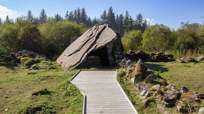
The portal tomb known as the Calf House in the Cavan Burren. Picture: Neil Jackman / tuatha.ie

The Cavan Burren may not be as well known or visited as its famous namesake in County Clare, but it too shares a similar wild landscape that teems with reminders of Ireland’s prehistoric past.

The Cavan Burren Geopark, which opened to the public in May 2014, is located south of the village of Blacklion, near the border between Cavan and Fermanagh. It is set on a distinct limestone plateau overlooked by Cuilcagh Mountain. Surrounded by planted forestry since the 1950s, it is widely recognised as an exceptional relict landscape. Geologically the site is located on limestone bedrock, that formed in a shallow tropical sea around 340 million years ago during the Carboniferous period. Many fascinating natural geological features can be seen here, such as a relict river bed with associated dolines and sinkholes where the river sank and disappeared underground, and huge boulders deposited by glaciers towards the end of the Ice Age.

 On the trail in the Cavan Burren. Picture: Neil Jackman / tuatha.ie
On the trail in the Cavan Burren. Picture: Neil Jackman / tuatha.ie

This remarkable plateau also contains some 5,000 years of archaeology, which can be explored via a network of about 10km of waymarked trails.

Along the Green Trail you will find Tullygobban Wedge Tomb, thought to be named after Gobán Saor, a master craftsman from Irish folklore. Wedge tombs are the most numerous of Ireland’s megalithic tombs, and date to the Chalcolithic period. This period falls between the Neolithic and Early Bronze Age, and is when the first copper tools and weapons began to be created and used in Ireland.

Also on this trail is the portal tomb (or dolmen) known as the Calf House. These tombs generally date to the earlier half of the Neolithic period, making this tomb likely to be well over 5,000 years old. The tomb’s unusual name comes from the fact that it was reused in the 19th and 20th centuries as an animal shelter.

Wedge tomb in the Cavan Burren.  Picture: Neil Jackman / tuatha.ie

The Cavan Burren’s Orange Trail contains another wedge tomb known as the Giant’s Grave, one of the largest and best-preserved wedge tombs in Ireland. The name of this tomb comes not only from its colossal size, but also from a local legend that tells of a giant who was competing for the love of a giantess. He attempted to jump over the nearby gorge (known now as the Giant’s Leap) and fell to his death, and was then buried in this tomb. The capstone has a large amount of ‘cup and ring’ rock art. Cup and ring decoration can be found on stone monuments all along the western seaboard of Europe, from the Iberian Peninsula to Scotland. There is also evidence of a surrounding kerb which may have held a cairn (a mound of stones covering the tomb).

A number of limekilns can also be found along the Orange Trail, where lime was produced to improve the soil and for the whitewashing of houses in the 19th and early 20th century.

The Purple and Red Trails pass by a clifftop promontory fort, likely constructed during the Late Bronze Age or Iron Age. One of the glacial erratics was used as a Mass Rock during Penal times in the 17th century, and you can also see the remains of 18th- and 19th-century agricultural field systems. Combined together, the field systems, kilns and ancient tombs, tell an interconnected tale of generations of farming communities, who lived, worked, and died in this hard landscape of stone.

The network of trails, interpretation panels and the small visitor hub offer a well-facilitated attraction that is focused on the heritage of the region. A series of interpretation posts help to animate the monuments, and larger panels give landscape context. A day out in the wild landscape here is a day well spent.

The unmanned visitor hub has accessible toilets, and a 1.2km accessible trail suitable for wheelchair users, though some of the longer trails include steep inclines and uneven surfaces.

You’ll find the Cavan Burren Geopark at co-ordinates Lat. 54.26519, Long. -7.887454, it is well signposted and located roughly 6km south of Blacklion.

  • Neil Jackman is an archaeologist, travel writer, and owner of tuatha.ie – an online membership for people who want to explore more of Ireland’s wonderful heritage

More in this section

Scene & Heard
Newsletter

Music, film art, culture, books and more from Munster and beyond.......curated weekly by the Irish Examiner Arts Editor.

Sign up
Cookie Policy Privacy Policy FAQ Help Contact Us Terms and Conditions

© Irish Examiner Ltd